|
2004: STATE OF UTAH,
OFF-ROAD GROUP ATTACK MEASURES THAT PROTECT THE SAN RAFAEL SWELL
Background
In May 2004, the "Shared Access Alliance" sued the
Bureau of Land Management to open up miles of alleged roads in the
San Rafael Swell area of Emery County, Utah. Read a
May
10, 2004, article in the Salt Lake Tribune. Many of these routes
were closed to motor vehicles for destroying fragile streamside
areas and the incredible natural beauty of the Swell.
Learn more about BLM's plan to place modest limits on
off-road vehicles--the plan that the off-roaders' lawsuit
attacked.
The Shared Access Alliance dropped its suit
within a month of filing, apparently getting a promise from the
State of Utah to attack the measures BLM put in place to protect the
Swell.
Read
the Salt Lake Tribune's June 8, 2004 story.
Per its secret agreement with off-road groups, the
State of Utah filed
a letter in August, 2004, threatening suit to
claim about 10 rights-of-way in the San Rafael Swell. Utah filed
a revised notice letter
in November 2004 modifying and expanding its claims. Read
a related news release from the
October 14, 2004 Greenwire.
June 2005: Utah files suit
Utah's suit claims seven of the ten routes discussed
in its notice letters -- including the Copper Globe, Link Flats,
Junes Bottom, Mexican Mountain route, Red Hole Draw, Seger's Hole,
Swasey's (or Sid's) Leap.
See the state's press release flacking the suit. Read an
Associated Press story
on the suit's filing and a
Salt Lake Tribune story
on the suit's filing.
Utah's and Emery County's suit has cost taxpayers
there $100,000.
See
an article in the August 16, 2005, "Emery County Progress."
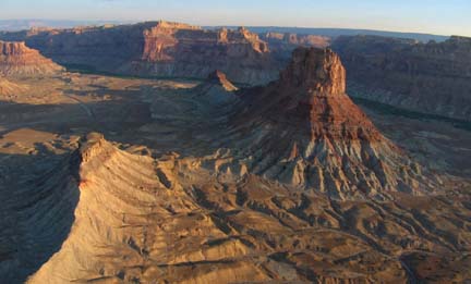
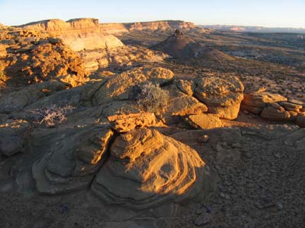
Photographs
See photos of some of the State of Utah's claimed
'constructed highways' including the
Swasey's
Leap trail inside the Mexican Mountain Wilderness Study Area,
Devil's Canyon. The State
claimed other routes as well that are not shown here. Look at
another batch of photographs added on June
29, 2005, the day the state filed its federal lawsuit:
June's Bottom,
Sid's Leap,
Link Flat,
Mexican Mountain,
Red Hole Draw,
Routes to Copper
Globe, and Seeger's Hole.
All photos courtesy the Southern Utah Wilderness Alliance.
Maps
General
locator map showing the location of the seven routes
claimed in the state's June 2005 lawsuit.
To get an idea of the location of the claimed
“constructed highways” in Utah’s August notice letter, check out the
following maps. Two of the routes are within the Mexican Mountain
Wilderness Study Area, more than half of the claimed routes are in
areas BLM identified as “roadless” just 5 years ago, and nearly all
are within areas proposed for wilderness protection by citizens.
Note that Utah has provided no maps with its claims; it
only identified the “sections” (or square mile) of land where the
roads are located, so some location information is approximate.
Note: The maps take a fair amount of time to
load, and may not work on all systems. Windows users can right-click
and save the file on their computers, which often works better.
Labyrinth
Canyon Junes Bottom A claimed “constructed highway” inside
an area of Labyrinth Canyon found by BLM to have wilderness
character in 1999, as well as citizen-proposed wilderness. BLM
closed this route to motor vehicles in its 2003 San Rafael Route
Plan.
Mexican
Mountain Wilderness Study Area Mexican Mountain & Swasey’s
Leap. Two allegedly “constructed highways” inside an area found to
have no roads - and closed to motor vehicles - in the 1980s by BLM
and protected since then as the Mexican Mountain Wilderness Study
Area (WSA).
Copper
Globe/Link Flats Copper Globe is a claimed “constructed
highway” bordering an area found by BLM to have wilderness character
in 1999 and adjacent to the Devil’s Canyon WSA, as well as
citizen-proposed wilderness. Link Flats is a claimed
“constructed highway” that is partly inside an area found by BLM to
have wilderness character in 1999, and partly within an area
proposed by citizens for wilderness protection. Small spurs to the
west were closed to motor vehicles in the 2003 San Rafael Route
Plan.
Devil's
Canyon & Picture Flat Devil’s Canyon is a claimed
“constructed highway,” part of which is inside an area found by BLM
to have wilderness character in 1999 and adjacent to the Devil’s
Canyon WSA, as well as within citizen -proposed wilderness. Much of
the route is a gravelly wash bottom. BLM closed the lion's share of
this route to motor vehicles in the 2003 San Rafael Route Plan.
Picture Flat is a claimed “constructed highway” inside an area
proposed by citizens for wilderness protection. BLM closed the
southern three miles of this route to motor vehicles in the 2003 San
Rafael Route Plan.
Red Hole
Draw & Short Canyon Red Hole Draw is a claimed “constructed
highway” inside an area proposed by citizens for wilderness
protection. BLM closed this route to motor vehicles in the 2003 San
Rafael Route Plan. Short Canyon - a claimed “constructed highway” in
the Coal Cliffs area. BLM closed this route to motor vehicles in the
2003 San Rafael Route Plan.
Lower
Muddy Creek Area Segers Hole A claimed “constructed highway”
is inside an area found by BLM to have wilderness character in 1999
and adjacent to the Muddy Creek WSA, as well as within
citizen-proposed wilderness. BLM closed to motor vehicles in
2003 the southern parts of the route that lie within the area the
agency found to have wilderness character.
|